





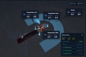
 Miros has introduced a 3D vessel view in its WaveSystem wave monitoring system, giving crews and operators a consolidated view of measured sea conditions around a vessel during weather-sensitive offshore operations.
The interface shows the location of each measurement source, its measurement area and key wave data in relation to the vessel. It provides an overview of the sea-state measurements relevant to offshore operations.
Wave conditions can vary around a vessel depending on wave direction, vessel heading, hull geometry, shielding and measurement location. Where multiple measurement sources are installed, comparing readings can help crews understand differences between conditions in specific areas.
Bridge and deck crews can use the view to assess conditions on the port and starboard sides, or near operational areas such as gangways and remotely operated vehicle (ROV) launch points. This can help identify differences in sea conditions that may affect planned activities.
The feature is available to WaveSystem subscribers worldwide at no additional cost. The visualisation shows measurement sources, areas and values in relation to the vessel; it does not reconstruct the sea surface in 3D.