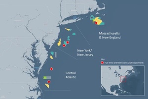
 TGS has completed a regional wind and metocean data collection campaign along the U.S. East Coast. This campaign involved deploying and simultaneously operating five offshore LiDAR buoys covering nearly 600 kilometres from Massachusetts to the Virginia/North Carolina border.
Data were collected from July 2022 through July 2024. All campaigns were conducted under TGS's multi-client approach, allowing multiple customers to access the same floating LiDAR data. TGS used the collected data to bias-correct its high-resolution Numerical Weather Prediction (NWP) model simulations, creating a validated high-resolution wind resource dataset along the U.S. East Coast. Both the quality-controlled measurement data and the bias-corrected NWP model data are being utilised by developers to inform and refine their bidding strategies for BOEM’s upcoming Central Atlantic offshore wind lease auction.


